At this intersection, hard by the Vine Street Expressway, we can see the results of community activism that did not stop this highway from being built but did help to mitigate its impacts.
In 1945, the City Planning Commission proposed a depressed 6-lane expressway along the Vine Street corridor as part of the regional highway network. It would connect to the existing Ben Franklin Bridge and new expressways along the Schuylkill and Delaware rivers (now I-76 and I-95, respectively).
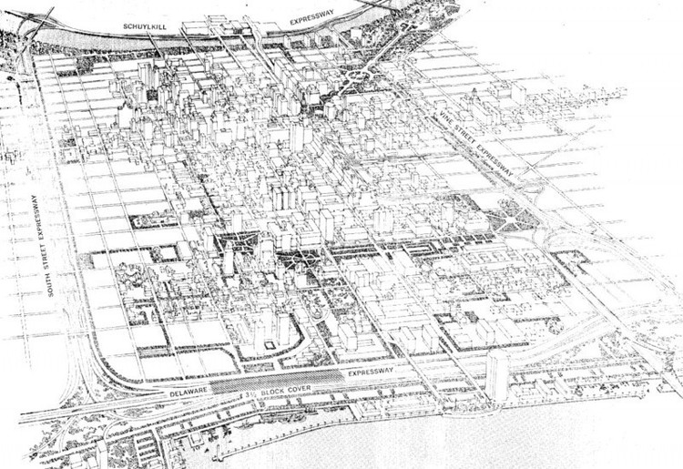
In 1947, Planning Commission executive director Robert Mitchell (later the chair of Penn's City Planning Department) proposed that Vine Street Expressway form part of a loop of expressways around Center City. In this plan, the Vine Street route would have been paralleled by another crosstown route running east to west between South and Lombard streets. The above image shows a bird's-eye rendering from the 1961 Center City Comprehensive Plan of what Center City would have looked like with the full expressway ring completed. It's worth noting that the blocks in Chinatown, as well as those along South and Lombard streets, appear blank on this rendering--either because they were intended for eventual redevelopment, or because they were simply regarded as too unimportant to depict.
The South/Lombard route became a focus of controversy and was successfully defeated. Alice Lipscomb, an African-Amerian activist, helped lead a multiracial coalition of communities along the route that generated enough political clout to influence the city and state governments to stop the project in the early 1970s. Lipscomb's group hired the architects Denise Scott Brown and Robert Venturi to carefully document South Street in photographs, demonstrating the value of the existing cityscape in a major symbolic victory against highway-led renewal.
In the same time period, Chinatown community members led a revolt against the Vine Street Expressway. These included property owners and merchants, especially those associated with Holy Redeemer Chinese Catholic Church and School, which is located just north of Vine Street at 10th. They also included a younger generation of more radical activists engaged in the Asian-American identity movement, who organized civil disobedience, as we will see at the next tour stop.
These actions were not successful in stopping the highway, but they did delay its construction and changed its design. Considerable affordable housing for single men, in the form of single-room occupancy hotels (SROs) around Franklin Square, was lost to the highway. This type of housing had been especially important to Chinatown's dispropotionately male society, the immigration of women having been sharply restricted for decades due to the 1882 Chinese Exclusion Act, repealed in 1943. Later in the tour we will see an affordable housing development that was built in Chinatown in the 1980s as a partial replacement for the lost SROs.
The delay in highway construction partly arose from the passage of new environmental laws in the early 1970s requiring environmental review of federal highway projects. In 1977, a new environmental impact statement was published, requiring mitigation measures which saved Holy Redeemer from the wrecking ball and reserved other land north of Vine Street for an affordable housing development on the block between Vine and Callowhill from 8th to 9th streets.
When the expressway was finally built in the late 1980s, it included the sound attenuation barrier you see here, complete with Chinese decorative motifs.
Domenic Vitiello & Zoe Blickenderfer. "The planned destruction of Chinatowns in the United States and Canada since c.1900," Planning Perspectives, 2018.