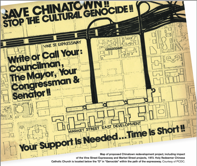
Stand at the corner of Race and 9th streets. Although it may not feel like an edge today, this intersection sits on the border between the urban renewal area and the lands that remained Chinatown. On this protest flyer from 1973, the lands to the east of here are shown as occupied by expressway ramps. Although the ramps were never built, the buildings along the east side of Ninth Street were demolished for an underground commuter rail tunnel linking SEPTA's Jefferson Station to existing rail lines to the north. Initially the city planned to redevelop the area without regard to Chinatown’s interests, and one proposal involved a school of podiatry that wanted to relocate to the site from elsewhere in Center City. Even though their buildings had already been taken, these redevelopment proposals still upset residents. A longtime Chinatown resident said: “I went down to City Hall, went to the mayor’s office, and I’m sayin’, I thought, ‘Podiatry is not gonna take my property! I’m not gonna give it up for a foot school!’ I was ranting and raving and crying. I was hysterical! Because it was a borderline of Chinatown. And it meant something to Chinatown. Not me personally, but Chinatown.”
One of the legacies of the 1960s-1970s activism against urban renewal in Chinatown was the formation of the Philadelphia Chinatown Development Corporation (PCDC), which fought for control of the land on the east side of Ninth Street. In 1985 PCDC was named the developer of this block. After building a cantilevered foundation over the rail tunnel, it sponsored housing projects with retail on the ground floor here. These projects are symbols of Chinatown’s resistance and even growth in the face of urban renewal.
Source: Kathryn E. Wilson (2015). Ethnic Renewal in Philadelphia's Chinatown: Space, Place and Struggle. Philadelphia: Temple University Press.
Image source: Mary Yee (2012). "The Save Chinatown Movement: Surviving Against All Odds." Pennsylvania Legacies 12(1). May. 24-31.